


Bucharest's bike network plan up for public consultation
Read next
Normal


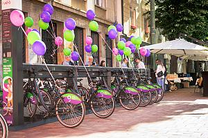
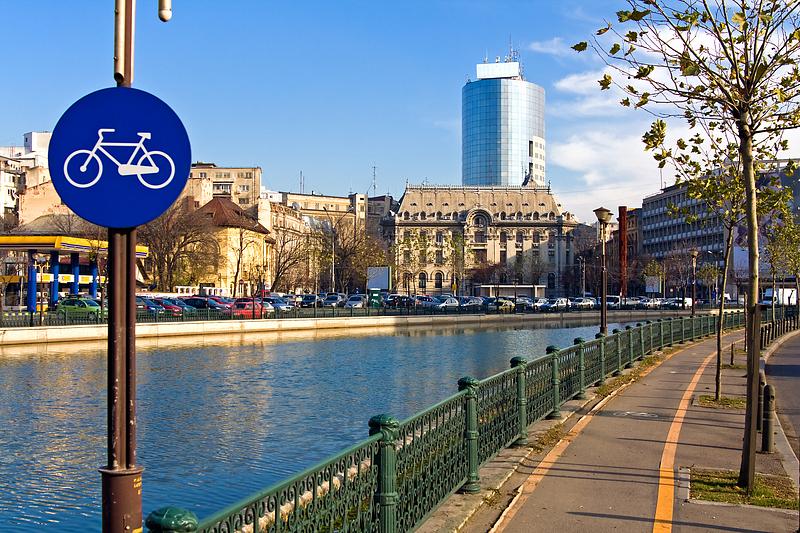
The Velo Masterplan, which covers the development of a network of bike lanes in the city, has been finalized and is now up for public consultation, the Bucharest City Hall announced.
The planned network is divided into two categories, main and secondary, and is meant to encourage active mobility, the Bucharest City Hall explained.
The main cycle paths proposed are:
Floreasca - Pipera - ZOO Băneasa will connect the north of the capital and the central area while serving the Pipera Platform. It has an estimated length of 16.23 kilometers and connects to the existing bike paths on Pipera Road and Fabrica de Glucoză /Petricani.
Dimitrie Cantemir - Obregia, which connects the central area with the southern part of the city and with Tineretului Park. It has an estimated length of 6.65 kilometers and does not connect to existing tracks.
Bucureştii Noi will connect the city's northwest part to Victoriei Square and Herăstrău Park. It has an estimated length of 8.91 kilometers and connects to the existing bike lanes on Kiseleff Road, Aviatorilor Boulevard, and Victoriei Square (extending to Calea Victoriei).
Victoriei – Giurgiului, which will connect the downtown to Giurgiului Road, while serving the Carol Park. It has an estimated length of 3.97 kilometers and connects to the existing lanes on Calea Victoriei, Splaiul Independentei and Giurgiului Road.
Colentina - Carol I, which will connect the center and the northeastern part of the city. It has an estimated length of 6.11 kilometers and connects to the existing lanes on Strada Petricani.
13 Septembrie - Ghencea will connect the center and the city's western part. It has an estimated length of 7.46 kilometers and connects to the route of existing tracks on Calea Victoriei, Splaiul Independenţei and Prelungirea Ghencea.
Pantelimon, which will connect the center and the eastern area, has an estimated length of 7.19 kilometers and does not connect to existing lanes.
Drumul Taberei - Elisabeta, which will connect the central and the western areas, has an estimated length of 7.76 kilometers and does not connect to existing lanes.
Traseul Liniei, which will connect the city's western and southern parts, has an estimated length of 14.94 kilometers. It connects to existing tracks on Splaiul Independenţei and Parcul Liniei.
Semicircular, which will establish a connection between the Cotroceni District and Piaţa Muncii, also connecting Piaţa Victoriei - Ştefan cel Mare - Obor. It has an estimated length of 8.88 kilometers and connects to existing lanes on Splaiul Independenţei, Strada Buzeşti, Calea Victoriei and Decebal Boulevard.
Splaiul Independenţei, which will connect Splaiul Independenţei and Lacul Morii, has an estimated length of 3.63 kilometers and connects to existing tracks on Splaiul Independensei and Lacul Morii.
Splaiul Unirii, which will connect the center and the southeast area, has an estimated length of 6.29 kilometers. It does not connect to existing lanes.
Unirii - Pallady, which will create the link between the center and the eastern area. It has an estimated length of 8.97 kilometers and connects to existing tracks on Decebal Boulevard and Liviu Rebreanu Street.
Iuliu Maniu, which will connect the Grozăveşti area and the western part of the city, has an estimated length of 6.74 kilometers. It connects to existing tracks on Splaiul Independenţei and Drumul Osiei.
Matei Basarab - Basarabia, which will connect the center and the eastern areas, has an estimated length of 6.18 kilometers and connects to existing lanes on Decebal Boulevard.
Rahova - Alexandriei, which will connect the center and the southwestern area, has an estimated length of 7.66 kilometers. It connects to existing tracks on Splaiul Independentiei and Calea Victoriei.
Inel Median Sud, which will link Berzei Street - Izvor Park and Calea Călăraşi, through the southern part of the capital's median ring, has an estimated length of 7.50 kilometers. It connects to existing tracks on Splaiul Independence and Berzei Street.
Inelul Median Nord covers the streets of Ştirbei Vodă, C.A. Rosetti, Maria Rosetti, Popa Petre, Zece Mese, Foișorul de Foc Square, as well as Traian, Mihăileanu Ştefan, Doctor Burghelea, Prof. Dr. Mihail Georgescu streets.
The plan is available here.
(Photo: Masezdromaderi | Dreamstime.com)
simona@romania-insider.com


